NYC Open Restaurants
Overview
The focus of my project was the NYC Outdoor Dining program. More specifically, to use several data points from this program and aggregate all dining options around NYC in a simple and efficient way.
Overview
The focus of my project was the NYC Outdoor Dining program. More specifically, to use several data points from this program and aggregate all dining options around NYC in a simple and efficient way.The NYC Open Restaurants project uses open source data from the Outdoor Dining program in addition with pandas, folium, and matplotlib to provide users with meaningful numerical and visual info about restaurants across the city, or in any specified zip code.

Background and Why?
The Outdoor Dining program was started in NYC to combat COVID spread, it has since become a favorite for many New Yorkers, and a permanent city program.In fact, recent studies show that many diners also favor dining outdoors rather than indoors. In the Citywide Mobility Survey held by the NYC DOT, an overwhelmingly broad percentage of those surveyed in Manhattan (> 80%) supported
repurposing curb space from free private vehicle parking to make room for the outdoor dining sheds and structures.
Table 1: Comfort Dining Outdoors v. Indoors
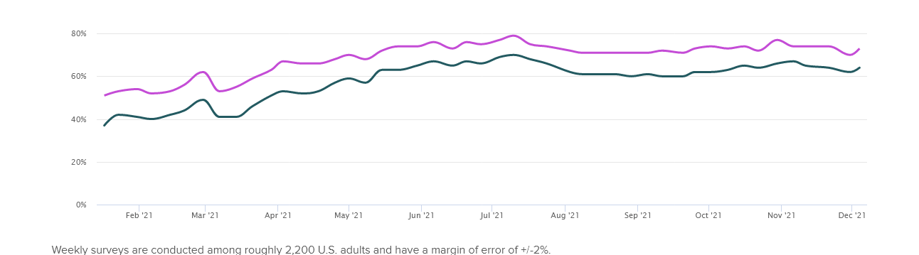
Source: Meyers, Alyssa. "Tracking the Return to Normal: Dining" Morning Consult, 2020
Technique
When I started this project I knew I wanted to achieve not only the most results, but also the most accurate.Thus, one of the first steps I took was to clean the imported Open Dining Program data via pandas and python.
Now with a clean data frame, the use of other libraries such as folium, matplotlib, regex, and branca were used to aggregate certain data points from the cleaned dataset. For example, zipping data points like restaurant name, latitude, and longitude were used to generate a folium map with relevant numerical and visual information. Regex was used to help users search by specified area.

Data
So we know New Yorkers support and even prefer outdoor dining over indoors. What does the data say about outdoor dining in NYC?Are there even many options to begin with? What type of outdoor dining options do restaurants provide?
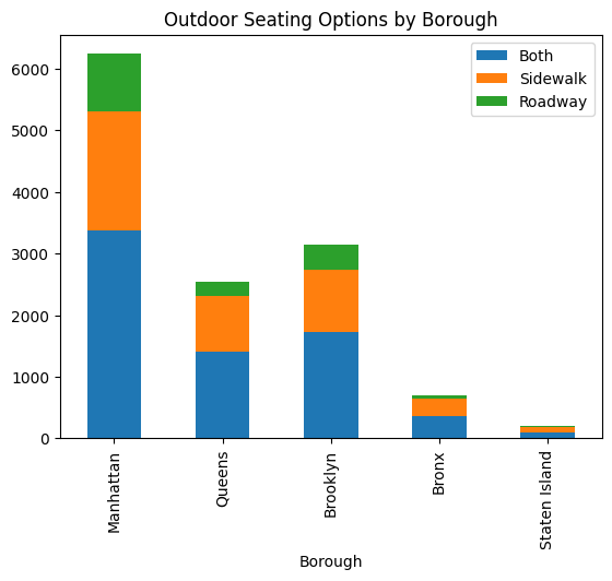
In the chart below, we see that are many thousands of outdoor dining restaurants across NYC. Although mostly concentrated in Manhattan, Queens, and Brooklyn.
Table 2: Outdoor Seating by Borough
Data: A Deeper Look
My program OpenRestaurantsNYC written in python takes data from the NYC Outdoor Dining program and provides markers for each restaurant in a visual friendly map, complete with filtering, and relevant information for the user.
Here we ask the program to show us all the open dining restaurants available around NYC. Check it out.
While a map of all outdoor restaurants is useful, we can also filter to a more specific or relevant area
Users can search by zip code, here the user searches by "10065" Users can also search by location, here the user searches by "Soho"